Kumaraparvatha aka KP aka Pushpagiri is one of those treks that should be present in every trekker's profile. The obvious question asked when any two trekkers from south India meet is "Have you been to KP?? ". Undoubtedly, one of the most beautiful, adventurous trekking spot in the western ghats.
I had been planning for a trek to Kumaraparvatha for the past two years and the finally scaled it successfully a couple of days ago..(20-21st Dec 2008).
After the Sakleshpura trek, I and Balu decided that we would trek KP this season. This time around we had a few omissions and additions to our normal trekking gang. Keerthy and Datta dropped out due to personal work and Bala dropped out since he was all set to trek Dalhousie. Newcomers to our trekking group, Srivatsan (kiran's colleague ), Karthik, Goutham's colleague at Google and my classmate at school and Shreyas, our friend from Mech dept joined us. So the group of 10 ( Balu, Gupta, Goutham, Kiran (with tripod :P ) , Rajesh, Karthik, Shreyas S, Srivatsa, Shreyas and me) were all set for KP.
Kumaraparvatha, also called as Pushpagiri is situated in the Somvarpet Taluk of Coorg District. The name Pushpagiri is the official name whereas the historical name for this place is kumaraparvatha. Many of the trekkers get confused with the names and think that Pushagiri and Kumaraparvatha are different peaks. Kumaraparvatha is at a height of 5624ft above sea level, one of the highest peaks in karnataka. The river Kumaradhara originates in this hills and flow towards Kukke Subramanya.
Kumaraparvatha can be accessed from two directions. The first one from the Somvarpet side. One has to reach a village called Bidalli and trek another 3 kilometers to Shanta Mallikarjuna temple to start the trek. The other route being from Kukke Subramanya. There is a road in the temple street that leads to the base of the hill. The trek from the Somvarpet side is easier and is mostly under the forest cover whereas the trek from the kukke side is more steep and through the grasslands.
We decided to trek from the Somvarpet side. There is a waterfall called Mallalli falls on the river Kumaradhara which we planned to visit on the way.
For the past few treks we have been hiring our own vehicle. It usually saves a lot of time and we need not wait for "very reliable" bus service. This time around we decided to travel in bus since the entry and exit point to the trek are easily accessible.
We boarded the bus to Somvarpet that leaves Bangalore at 11PM. We had a nice time chatting with each other before fell asleep. However, nonstop Balu was still chitchatting until 1 in the night when an irritated uncle shouted at him to stop, after which all of us peacefully slept :P .
We reached Somvarpet at around 5:45 in the morning. Our bus to Bidalli was at 7:30 in the morning and we were left with a lot of time to spare. There was 2 other trekking groups of around 10 people each that had come in our bus. Instead of wasting time by waiting for the bus, we decided to take auto towards Mallalli falls around 25 kilometers from Somvarpet. After bargaining for the fare of Rs 225 per auto, we took three autos and went to Hanchinalli. Hanchinalli is 2 kilometers before Bidalli and we need to take a diversion here to go to Mallalli falls.

We left our baggage in Ponnappa's place who agreed to prepare breakfast for us and started towards the falls at 7 in the morning. Minchalli falls is around 2.5 kilometers from here and we need to take a road that passes next to Ponnappa's place to the falls. After walking for around half an hour, we saw the view of the Kumaradhara river gushing down into the valley. We got down near the falls and had our bath in the ice-cold water. The water in the falls was less but the scenery was nice. Our new official photographer (after Datta's retirement), Kiran ,had his tripod ready and started applying his photographic skills to capture the not-so-visible scenes than the obvious pictures. :)

After our bath, we started back to Ponnappa's place. I dunno what made me crazy, I and Karthik started to search for a shortcut to the top of the valley. We climbed through the bushes until a vertical rock halted our progress and made us return back to base. The "Shortcut idea" made us completely tired,adding just a dozen of scratches to our hands and legs. But still whats the fun in trekking if you are taking the path everyone takes..U need to make your own!!! :) We silently reached back to Ponnappa's place by 9:45 and had our breakfast.
 View of KP from Somvarpet side
Normally trekkers start the trek to KP from either Bidalli or the Shanta Mallikarjuna temple. We are the set of those crazy people who make ordinary things special. We made up for not trekking from the Kukke side by trekking a longer route. With 5 kilometer walk to falls already done, we started walking towards the Shanta Mallikarjuna temple, 6 kilometers away in the scrotching sun. We went past Bidalli cross, Heggademane and reached the temple. We asked for directions from the locals and reached the forest checkpost by 12:30. Checkpost is around 6 kilometers from Hanchinalli and around 4 kilometers from Bidalli. We paid the trekking fee of Rs 115 per person at the checkpost and went past the hanging bridge into the forest. The pushpagiri peak is around 5.5 kilometers from the forest checkpost and can be reached in around 3-4 hours. One can collect water from the stream near the hanging bridge. Water is available until 2 kilometers past checkpost and one has to carry enough water until you reach the peak.
 Viewpoint
We had our lunch in the forest and reached the viewpoint by around 3 in the afternoon. The view of the mountain ranges was good and we had covered substantial altitude under the forest cover. After the viewpoint, we came out of the forests and were able to get a clear picture of the mountains around. There are 3 quite steep rocks which are around 60 degree inclination. After the rocks, it is just a matter of 10 minutes by the time u reach the peak. We reached the peak at 4:30. We had enough time to setup the tents and the campfire. Balu and Shreyas went in search of water in the nearby stream whereas the others started setting up the tent and collected twigs for the campfire.
There is lot of space to set up the tents for the night. We put our tent just below the peak. By 6:30 in the evening, the whole of the mountain was covered with mist and cold wind was blowing at full speed. It was just the beginning. The cold winds haunted us until the morning and most of us were hardly able to sleep because of cold. We setup the camp fire,had our dinner and went off to bed by 8 at the night. By 1 in the midnight, most of us were shivering due to cold and somehow killed time until the morning. It is one of those night where you feel that the nights are too long to pass. Had a similar experience in Yedakumeri railway station few months back.

 Shadow of KP during sunrise
We got up at 6 in the morning and rushed to the peak to catch the sunrise. It is astonishing that we people who rarely get up until few hours (read 3 to 4 hours) after sunrise wait to catch the sight of the sun rising behing the sea of clouds here. The whole of the sky and the other mountain peaks were covered with cloud and we saw the amazing view of the sun rising from the horizon. At around 6:30 in the morning, a large troop of NCC cadets came to the peak. They were around 80 boys and girls in all and their speed of trekking was just amazing.

 The gang with a few missing people
There are three peaks in this hill range, Kumaraparvatha, Sheshaparvatha and Siddhaparvatha. Out of these, Siddhaparvatha is inaccessible. When seen from the Kukke side, Sheshaparvatha and Kumaraparvatha appear to be one.

We started our descent towards Kukke subramanya at around 7:45 in the morning.Kukke Subramanya from the peak of Kumaraparvatha is around 13 kilometers. After getting down the Kumaraparvatha, we reached the top of Sheshparvatha. Many of the trekkers who climb from Kukke side get confused with Sheshaparvatha to be Kumaraparvatha. From the Kukke side, one has to cross Sheshaparvatha and trek for another one hour to reach Kumaraparvatha. The view from the top of Sheshaparvata is amazing. One can see the town of Kukke, the grasslands and the forest check post at Kukke side from here. The steep hill next to Sheshparvata, MaariGundi made us think if we can perform rock climbing on it!!!
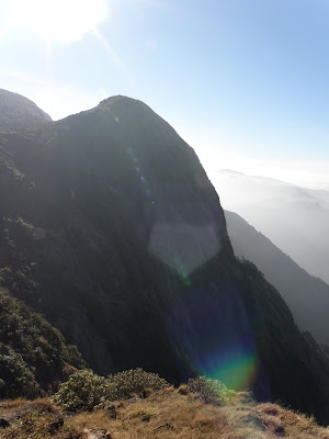 Maarigundi
 View from the Kukke side
After crossing the grasslands, we saw the famous "Mantapa". One can camp near the Mantapa when trekking from Kukke side. At around 10:45 we reached the forest check post who checked our receipts and let us pass. The forest officer was quite friendly and chatted with us about the various facilities that forest dept provides etc etc. Bhattara mane is just 5 minutes away from the checkpost. We had told for lunch at bhattara mane before leaving from Bangalore. Bhattara Mane was full of trekkers, around 30-40 people. We had our lunch and left Bhattara Mane at 1 and reached the base of the peak at 3 in the afternoon. The base of the peak is around 5 kilometers from Bhattara mane.
Then there is a road that leads to the Kukke temple which is 1km from the base of the peak. We reached Kukke and had a bath in the Kumaradhara river and spent some time roaming around kukke. We found a cave in the main road of Kukke. One has crawl on four legs through this cave. The cave had loads of bats that flew just a few inches from us. We struggled our way through the cave escaping being hit by the bats. We visited the temple and boarded our bus back to Bangalore at 9:30 in the night.
An amazing trek in which we walked around 30 kilometers during the two days. One of my favourite treks and looking forward to trek from the kukke side.
Time to plan for the next trek guys...where is it to????




 Posts

