Wednesday, December 31, 2008

Dasvidaniya

Just a couple of hours left in the year 2008..Time to say good bye to 2008 and welcome 2009. Looking back, this has been quite an eventful year for me personally and professionally. Remembering ( and publicizing :) ) moments of 2008....
  • Learnt Swimming!! - A long time pending one.. Now at least I can drag myself to shore if I fall into a pool.

  • Learnt four-wheeler and got a license.
  • Watched loads of movies .
    Saw the record number of movies in this year. Seen at least 70-80% of the Bollywood released this year, all thanks to my Movie-buff friend, Balu.

  • Became a fan of Kannada Novels - Lately started reading more Kannada novels than the English ones. I am finding them more interesting and easy to relate than the Sheldon's and the Archer's.

  • Been on 6 trips to different places throughout this year.

  • Completed trek of Sakleshpura Railway Track and Kumaraparvatha, about which I had been planning for a long time.

  • Did rock climbing and Parasailing... How about Bongee Jumping next!!

  • Professionally, I did do some work on development of the product I am working on :-)

  • Finally , became a blogger!!!

    Looking forward to 2009 with new aspirations, searching for new inspirations.. before that Dasvidaniya to 2008...

Saturday, December 27, 2008

Kumaraparvatha Trek

Kumaraparvatha aka KP aka Pushpagiri is one of those treks that should be present in every trekker's profile. The obvious question asked when any two trekkers from south India meet is "Have you been to KP?? ". Undoubtedly, one of the most beautiful, adventurous trekking spot in the western ghats.

I had been planning for a trek to Kumaraparvatha for the past two years and the finally scaled it successfully a couple of days ago..(20-21st Dec 2008).

After the Sakleshpura trek, I and Balu decided that we would trek KP this season. This time around we had a few omissions and additions to our normal trekking gang. Keerthy and Datta dropped out due to personal work and Bala dropped out since he was all set to trek Dalhousie. Newcomers to our trekking group, Srivatsan (kiran's colleague ), Karthik, Goutham's colleague at Google and my classmate at school and Shreyas, our friend from Mech dept joined us. So the group of 10 ( Balu, Gupta, Goutham, Kiran (with tripod :P ) , Rajesh, Karthik, Shreyas S, Srivatsa, Shreyas and me) were all set for KP.

Kumaraparvatha, also called as Pushpagiri is situated in the Somvarpet Taluk of Coorg District. The name Pushpagiri is the official name whereas the historical name for this place is kumaraparvatha. Many of the trekkers get confused with the names and think that Pushagiri and Kumaraparvatha are different peaks. Kumaraparvatha is at a height of 5624ft above sea level, one of the highest peaks in karnataka. The river Kumaradhara originates in this hills and flow towards Kukke Subramanya.

Kumaraparvatha can be accessed from two directions. The first one from the Somvarpet side. One has to reach a village called Bidalli and trek another 3 kilometers to Shanta Mallikarjuna temple to start the trek. The other route being from Kukke Subramanya. There is a road in the temple street that leads to the base of the hill. The trek from the Somvarpet side is easier and is mostly under the forest cover whereas the trek from the kukke side is more steep and through the grasslands.

We decided to trek from the Somvarpet side. There is a waterfall called Mallalli falls on the river Kumaradhara which we planned to visit on the way.

For the past few treks we have been hiring our own vehicle. It usually saves a lot of time and we need not wait for "very reliable" bus service. This time around we decided to travel in bus since the entry and exit point to the trek are easily accessible.

We boarded the bus to Somvarpet that leaves Bangalore at 11PM. We had a nice time chatting with each other before fell asleep. However, nonstop Balu was still chitchatting until 1 in the night when an irritated uncle shouted at him to stop, after which all of us peacefully slept :P .

We reached Somvarpet at around 5:45 in the morning. Our bus to Bidalli was at 7:30 in the morning and we were left with a lot of time to spare. There was 2 other trekking groups of around 10 people each that had come in our bus. Instead of wasting time by waiting for the bus, we decided to take auto towards Mallalli falls around 25 kilometers from Somvarpet. After bargaining for the fare of Rs 225 per auto, we took three autos and went to Hanchinalli. Hanchinalli is 2 kilometers before Bidalli and we need to take a diversion here to go to Mallalli falls.


We left our baggage in Ponnappa's place who agreed to prepare breakfast for us and started towards the falls at 7 in the morning. Minchalli falls is around 2.5 kilometers from here and we need to take a road that passes next to Ponnappa's place to the falls. After walking for around half an hour, we saw the view of the Kumaradhara river gushing down into the valley. We got down near the falls and had our bath in the ice-cold water. The water in the falls was less but the scenery was nice. Our new official photographer (after Datta's retirement), Kiran ,had his tripod ready and started applying his photographic skills to capture the not-so-visible scenes than the obvious pictures. :)


After our bath, we started back to Ponnappa's place. I dunno what made me crazy, I and Karthik started to search for a shortcut to the top of the valley. We climbed through the bushes until a vertical rock halted our progress and made us return back to base. The "Shortcut idea" made us completely tired,adding just a dozen of scratches to our hands and legs. But still whats the fun in trekking if you are taking the path everyone takes..U need to make your own!!! :) We silently reached back to Ponnappa's place by 9:45 and had our breakfast.

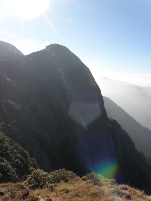
View of KP from Somvarpet side

Normally trekkers start the trek to KP from either Bidalli or the Shanta Mallikarjuna temple. We are the set of those crazy people who make ordinary things special. We made up for not trekking from the Kukke side by trekking a longer route. With 5 kilometer walk to falls already done, we started walking towards the Shanta Mallikarjuna temple, 6 kilometers away in the scrotching sun. We went past Bidalli cross, Heggademane and reached the temple. We asked for directions from the locals and reached the forest checkpost by 12:30. Checkpost is around 6 kilometers from Hanchinalli and around 4 kilometers from Bidalli. We paid the trekking fee of Rs 115 per person at the checkpost and went past the hanging bridge into the forest. The pushpagiri peak is around 5.5 kilometers from the forest checkpost and can be reached in around 3-4 hours. One can collect water from the stream near the hanging bridge. Water is available until 2 kilometers past checkpost and one has to carry enough water until you reach the peak.

Viewpoint

We had our lunch in the forest and reached the viewpoint by around 3 in the afternoon. The view of the mountain ranges was good and we had covered substantial altitude under the forest cover. After the viewpoint, we came out of the forests and were able to get a clear picture of the mountains around. There are 3 quite steep rocks which are around 60 degree inclination. After the rocks, it is just a matter of 10 minutes by the time u reach the peak. We reached the peak at 4:30. We had enough time to setup the tents and the campfire. Balu and Shreyas went in search of water in the nearby stream whereas the others started setting up the tent and collected twigs for the campfire.

There is lot of space to set up the tents for the night. We put our tent just below the peak. By 6:30 in the evening, the whole of the mountain was covered with mist and cold wind was blowing at full speed. It was just the beginning. The cold winds haunted us until the morning and most of us were hardly able to sleep because of cold. We setup the camp fire,had our dinner and went off to bed by 8 at the night. By 1 in the midnight, most of us were shivering due to cold and somehow killed time until the morning. It is one of those night where you feel that the nights are too long to pass. Had a similar experience in Yedakumeri railway station few months back.


Shadow of KP during sunrise

We got up at 6 in the morning and rushed to the peak to catch the sunrise. It is astonishing that we people who rarely get up until few hours (read 3 to 4 hours) after sunrise wait to catch the sight of the sun rising behing the sea of clouds here. The whole of the sky and the other mountain peaks were covered with cloud and we saw the amazing view of the sun rising from the horizon. At around 6:30 in the morning, a large troop of NCC cadets came to the peak. They were around 80 boys and girls in all and their speed of trekking was just amazing.


The gang with a few missing people

There are three peaks in this hill range, Kumaraparvatha, Sheshaparvatha and Siddhaparvatha. Out of these, Siddhaparvatha is inaccessible. When seen from the Kukke side, Sheshaparvatha and Kumaraparvatha appear to be one.


We started our descent towards Kukke subramanya at around 7:45 in the morning.Kukke Subramanya from the peak of Kumaraparvatha is around 13 kilometers. After getting down the Kumaraparvatha, we reached the top of Sheshparvatha. Many of the trekkers who climb from Kukke side get confused with Sheshaparvatha to be Kumaraparvatha. From the Kukke side, one has to cross Sheshaparvatha and trek for another one hour to reach Kumaraparvatha. The view from the top of Sheshaparvata is amazing. One can see the town of Kukke, the grasslands and the forest check post at Kukke side from here. The steep hill next to Sheshparvata, MaariGundi made us think if we can perform rock climbing on it!!!

Maarigundi

View from the Kukke side

After crossing the grasslands, we saw the famous "Mantapa". One can camp near the Mantapa when trekking from Kukke side. At around 10:45 we reached the forest check post who checked our receipts and let us pass. The forest officer was quite friendly and chatted with us about the various facilities that forest dept provides etc etc. Bhattara mane is just 5 minutes away from the checkpost. We had told for lunch at bhattara mane before leaving from Bangalore. Bhattara Mane was full of trekkers, around 30-40 people. We had our lunch and left Bhattara Mane at 1 and reached the base of the peak at 3 in the afternoon. The base of the peak is around 5 kilometers from Bhattara mane.

Then there is a road that leads to the Kukke temple which is 1km from the base of the peak. We reached Kukke and had a bath in the Kumaradhara river and spent some time roaming around kukke. We found a cave in the main road of Kukke. One has crawl on four legs through this cave. The cave had loads of bats that flew just a few inches from us. We struggled our way through the cave escaping being hit by the bats. We visited the temple and boarded our bus back to Bangalore at 9:30 in the night.

An amazing trek in which we walked around 30 kilometers during the two days. One of my favourite treks and looking forward to trek from the kukke side.

Time to plan for the next trek guys...where is it to????

Ponder this!!

An Idle mind is devil's workshop.. I have been jobless this week. Killing time big time.. Just then thought I can get back to my habit of solving puzzles and found this.. Try it out..

A monkey (hypothetical one) is trying to scale a slippery pole (Does this sounds familiar?) that is 10,000 feet high (obviously hypothetical!!). While trying to climb up the pole, the monkey starts with the second number in the Fibonacci series (1) and goes up by one foot. The pole being very slippery he slips and slides down by a distance equal to the previous number in the series which in this case is again 1. Thus after the first attempt he is back to where he started, 0. He tries harder in each subsequent attempt and manages to go up by the next number in the series, but unfortunately again slides back by the distance of the previous number in the series. Thus in his second attempt he manages to go up by 2 feet and then slides down by 1, a net gain of 1 feet. Like wise in the third attempt it goes up by 3 feet and slides down by 2 and so on.

For every 3 attempts he slips by an additional cumulative distance of 10 feet. Obviously the monkey is getting tired! Thus after the 3rd attempt the monkey slips by an additional 10 feet, after the 6th slips by an additional 20 feet, after the 9th slips by an additional 30 feet and so on. Also, he cannot slip back any further than the ground level (0 feet). (We don’t expect the monkey to slip underground.)

Finally here is the question. How many attempts would the monkey take to reach the top of the pole,if at all??

Update:: One attempt consists of climbing up and slipping down..and there is nothing like an half attempt ;-)

Monday, December 22, 2008

Yana Trek

I am just back from a wonderful trek to KP. Will be writing about that shortly. Before that penning down my trekking experience to Yana.

May 2006 ...

It was the time of our sixth semester. It had been a long time after our last trip to chennai for the Shaastra event. We wanted a break and an excuse to miss our college. And we got a reason to do just that. One of our college lecturer was getting married and the marriage was in Shimoga, around 270 kilometers from Bangalore. We thought we would attend the wedding and also trek Yana and visit other places. Like they say in kannada, "Swamy karya, Swakarya". :)

We were seven of us in all, Balu, keerthy, Gupta, Pavan , Datta, Sudhindra and Me. We boarded the bus to Sirsi, a small town in Uttara Kannada District around 425 from Bangalore. We reached Sirsi at around 5:30 in the morning. There is a bus that leaves towards Yana at 7 in the morning. We boarded that bus and got down at a place called Vaddi cross. Yana is around 17 kilometers from here. There is a motor able road from here until 3 kilometers before Yana. We had to walk all the way with our luggage among the canopy of the forest trees.

We reached the Yana Cross, where the road ends and entered the deep forests for the final stretch to Yana. Amongst the forest trees we were able to see the magnificent structure of the 2 rocks, Bhairaveshwara Shikara and Mohini Shikara. We reached the place around 12-1, I guess. The two rocks are a treat to watch. We roamed around the caves of the Bhairaveshwara shikara and visited the temple.


Bhairaveshwara Shikara

Bhairaveshwara shikara is around 120 ft high and taller and larger of the two rocks and is a home of loads of bats and honeybee colonies. We were constantly told by the locals and fellow trekkers not to make loud noises since it may disturb the bees and bats. Mohini shikara is around 90 ft high. There are many theories on the formation of these rocks and a mythological story too which u can find here.


Mohini Shikara

My initial assumption was that we can climb to the top of the peak but was disappointed when we were told that it was not possible. But recently, in a movie, I saw a scene where the hero takes the heroine to the peak !!! So, still confused if it can be done.

We had our lunch near the base of the Bhiraveshwara shikara. We didn't go to the base of the mohini shikara since we had get into the woods again and our plan was to reach back to Shimoga that night. We were told that there is a bus to Kumta in the afternoon which never arrived. The condition of the road that leads to Kumta was in a pathetic condition covered with at least 2 feet of red soil. We had a real tough time walking in the red desert each time watching our feet disappear in the sand.

The bus facility and condition of the roads needs serious attention from the tourism department. Such natural wonders needs to be preserved and maintained so that it can attract more tourists.

Balu and Gupta enquired the locals for jeep that could take us to the main road where we can find a bus to kumta. After a lot of effort, one of the estate owners sent their jeep to drop us to the main road, From there, we got a lift to Kumta in an open tempo and that was a real fun ride.

All in all, the whole day we walked around 22-24 kilometers, a day of hard hiking in the forest and the red soil filled roads. Disappointed with Yana, that I couldn't climb it ,we reached Shimoga at around 11 in the night.


The next day we attended the marriage of our lecturer and left to Jog Falls. We reached Jog Falls around 2-3 in the afternoon and our bus to Bangalore was at 7 in the evening at the Jog Falls gate. As everyone knows, Jog Falls is one of the wonderful waterfalls on Sharavati river where the water falls from a height of 829 ft.

Since it was an off-season, before the monsoons , there was hardly any water in the falls. Out of the 4 parts of Jog, Raja and Rani were almost non-existent,I must say, and Rocket was a small stream of water and no roars from the Roarer was heard. :( . Since we had lot of time to kill, we thought we can do things interesting. We started to climb down the Jog falls. There is a visible path made of stones boulders and it took around one hour to reach to the base of the Jog Falls. This was an awesome experience to see the Jog from right below. The volume of water that was gushing down was quite high, though it was looking very minimal from the view point. We took bath and after photo sessions by our officials photographers, Datta and Pavan , we started our climb back to the top.


View from the bottom of Jog

The trek to the bottom of the Jog and back to the top was quite tough compared to the hike to Yana. The birthday boy, Sudhindra, had a tough time climbing back to the top. With constant scoldings from the Big Brother,Gupta, he finally made it..

We had some snacks and finally boarded the bus to Bangalore ending our rather tiring trip to Yana and Jog Falls.

The Gang minus PK

Saturday, December 13, 2008

Sunday, December 7, 2008

Its Fun to Fly

Each one of us during our childhood would have envied the birds flying high in the sky and would have wished if even we could have flew..

This wish was finally fulfilled when a few of us went parasailing near Hoskote. After the first attempt to go parasailing got cancelled due to rain, few people dropped off. We were left with four of us to go skywards. Thanks to one of my late-latif friend,we reached Hoskote on our bikes by 11:30.

The para sailing is organised in the Hoskote lake bed area around 40 kilometers from bangalore.The day was not too windy and we had to wait for the wind to catch up to get a nice flight. The parachute was attached to our back and we are tied to a gypsy using a long rope. Finally my turn came. The gypsy moved forward and the wind lifted me off the ground. It was a wonderful experience to get a feel of flying. The height of the flight was around 150 ft and the view from the top was awesome. The flight lasted around 2 minutes but the experience was a memorable one...

How I wish I could fly everyday to office,beating the traffic :)

(PS :: Have been waiting for the video from my friend..will upload that soon)

Tuesday, December 2, 2008

ಚೆಂದಿರ ನಗುತಿರುವ...

ನಿನ್ನೆ ರಸ್ತೆಯಲ್ಲಿ ಬರುವಾಗ ಹಾಗೆ ಸುಮ್ಮನೆ ಆಕಾಶದತ್ತ ಕಣ್ಣಾಯಿಸಿದೆ. ಪಡುವಣದ ಆಗಸದಲ್ಲಿ ಚೆಂದಿರ ಒಮ್ಮೆ ತುಸು ನಕ್ಕ ಹಾಗೆ ಅನಿಸಿತು. ಮತ್ತೆ ನೋಡಿದೆ. ಹೌದು, ಚೆಂದಿರ ಭೂಮಿಯ ನೋಡಿ ಮುಗುಳ್ನಗುತ್ತಿದ್ದಾನೆ. ( ನಾವು ಕಳಿಸಿದ ಚಂದ್ರಯಾನ ಅಲ್ಲಿಗೆ ತಲುಪಿತು ಎಂದು ಹೇಳಲು ಇರಬಹುದೇ?? :) )

ಕವಿಸಮಯ ಹಾಗಿರಲಿ.. ನಿಜ ಸಂಗತಿ ಇದು..ಸಂಜೆ ಆಕಾಶದಲ್ಲಿ ಒಂದು ಅಪರೂಪವಾದ ಘಟನೆಗೆ ನಾವು ಸಾಕ್ಷಿಯಾಗಿದ್ದೇವೆ. ಇದನ್ನು ವಿಜ್ಞಾನಿಗಳು ಸಮ್ಮಿಲನ (Celestial Rendevous) ಎಂದು ಕರೆಯುತ್ತಾರೆ. ಶುಕ್ರ (venus) ಮತ್ತು ಗುರು (Jupiter) ಗ್ರಹಗಳು ಸೂರ್ಯನ ಸಮೀಪ ಸುತ್ತುವಾಗ ಭೂಮಿಯಿಂದ ನೋಡಿದಾಗ ಹತ್ತಿರ ಇದ್ದ ಹಾಗೆ ಕಂಡಿತು. ಈ ಗ್ರಹಗಳು ಆಕಾಶದಲ್ಲಿ ಚೆಂದ್ರನ ಮೇಲೆ ಕಂಡು ಈ ಮನೋಜ್ಞ ದೃಶ್ಯ ಸೃಷ್ಟಿಯಾಯಿತು.

ಚುರುಮುರಿಯಲ್ಲಿ ಇದರ ವೀಡಿಯೊ ನೋಡಿ


ಸ್ವಲ್ಪ ಹೆಚ್ಚು ವಿಷಯ ಇಲ್ಲಿ

Monday, December 1, 2008

What type is your blog ??

Each of your blog post definitely says something about you..It depicts your way of thinking and style of writing.

I found a website that says your blog type.. It analyzes (if I can say that!!) your blog posts and classifies your blog.

This is what it said about my blog ::

( Wrong picture though :( !!)

And also analyzed my blogging mind

So what is your blog type?? and what does it say about you??

Tuesday, November 25, 2008

Interesting!!

I just couldn't stop myself from sharing this interesting article and yet another awesome series of pictures from Big Picture

1) History's greatest conspiracy theories...

http://www.telegraph.co.uk/news/picturegalleries/howaboutthat/3477148/The-greatest-conspiracy-theories-in-history.html

Lists a number of historical events that may have the unknown side to it.. Not at all surprised to find the Moan Landing Hoax at #4..


2) Awesome pictures of the International Space Station..

http://www.boston.com/bigpicture/2008/11/the_international_space_statio.html

Monday, November 24, 2008

ಕಡಲೆಕಾಯಿ, ಕಡಲೆಕಾಯಿ!!!

ತಾಜಾ ತಾಜಾ ಕಳ್ಳೆಕಾಯ್
ಗರಮಾಗರಂ ಕಡಲೇಕಾಯಿ,
ಬೆಂಗಳೂರು ನಗರದ ಬಸವನ ಪರಿಷೆಯ ಬಡವರ ಬಾದಾಮಿ ಕಳ್ಳೇಕಾಯ್‌....

ಹೌದು ಈ ಹಾಡು ಕೇಳಿದೊಡನೆ ನೆನಪಿಗೆ ಬರೋದು ನಮ್ಮ ಬಸವನಗುಡಿಯ ಕಡಲೇಕಾಯಿ ಪರಿಷೆ.. ಕಡ್ಲೆಕಾಯಿ ಪರಿಷೆ ಮತ್ತೆ ಬಂದಿದೆ. ಕಾರ್ತಿಕ ಮಾಸದ ಕಡೆಯ ಸೋಮವಾರದಿಂದ ನಡೆಯುವ ಈ ಜಾತ್ರೆಯ ಗತ್ತು, ವೈಭವವೇ ಬೇರೆ. ಬೆಂಗಳೂರಿನ ವಿಶೇಷಗಳಲ್ಲಿ ಇದು ಕೂಡ ಒಂದು. ಕಾಲಂತರದಿಂದ ನಡೆದು ಬಂದಿರುವ ಈ ಆಚರಣೆಯಲ್ಲಿ ನಾನಾ ಹಳ್ಳಿಗಳಿಂದ ರೈತರು ತಮ್ಮ ರಾಶಿ ರಾಶಿ ಕಡಲೇಕಾಯಿ ಬೆಳೆಯನ್ನು ತಂದು ಮಾರುತ್ತಾರೆ. ಬಸವನಿಗೆ ಕಡ್ಲೇಕಾಯಿಯ ವಿಶೇಷ ಪೂಜೆ ನಡೆಯುತ್ತದೆ.

ಕಡ್ಲೇಕಾಯಿ ಪರಿಷೆಗೆ ತನ್ನದೇ ಆದ ಐತಿಹ್ಯವಿದೆ. ಹಿಂದೆ ಈ ಪ್ರದೇಶದ ಹೆಸರು ಸುಂಕೇನಹಳ್ಳಿ. ಇಲ್ಲಿ ಅಧಿಕವಾಗಿ ಶೇಂಗಾ ಅಂದ್ರೆ ಕಡಲೇಕಾಯಿ ಬೆಳೆಯುತ್ತಿದ್ದರು. ಇಲ್ಲಿನ ರೈತರು ತಾವು ಬೆಳೆದ ಕಡಲೆ ಕಾಯಿಯನ್ನು ರಾಶಿ ಮಾಡಿದಾಗ ಬಸವ ತಿನ್ನಲು ಬರುತ್ತಿತಂತೆ. ತಮ್ಮ ಬೆಳೆಯನ್ನು ಯಥೇಚ್ಛವಾಗಿ ತಿಂದು ಹೋಗುತ್ತಿತ್ತಂತೆ. ಒಂದು ದಿನ ರೈತರು ಆ ಬಸವನ ಬೆನ್ನಟ್ಟಿ ಹೋದರಂತೆ. ಆಗ ಬಸವ ಈಗ ಗುಡಿ ಇರುವ ಸ್ಥಳದಲ್ಲಿ ಬಂದು ನಿಂತು ಕಲ್ಲಾದನಂತೆ. ರೈತರಿಗೆ ತಾವು ಮಾಡಿದ ತಪ್ಪಿನ ಅರಿವಾಯಿತು. ಶಿವನ ವಾಹನನಾದ ಬಸವ ತಾನೇ ಸ್ವತಃ ಕಡಲೆ ಕಾಯಿ ತಿನ್ನಲು ಬಂದರೂ ನಾವು ಹೊಡೆದು ಓಡಿಸಿದೆವಲ್ಲ ಎಂದು ಮರುಗಿದರಂತೆ . ಅದಕ್ಕಾಗಿ ಪ್ರತಿವರ್ಷ ತಮ್ಮ ಮೊದಲ ಕಡಲೆಕಾಯಿ ಬೆಳೆಯನ್ನು ಈ ಬಸವಣ್ಣನಿಗೆ ಅರ್ಪಿಸಲು ಇಲ್ಲಿ ಕಡಲೆ ಕಾಯಿ ಪರಿಷೆ (ಜಾತ್ರೆ) ನಡೆಸುತ್ತಾರೆ.

ಇತ್ತೀಚಿನ ನಗರೀಕರಣ, ಆಧುನಿಕತೆಯ ಬೇಗೆಯಲ್ಲಿ ಪರಿಷೆ ಸ್ವಲ್ಪ ಕಳೆಗುಂಡಿದರೂ, ಸಾಂಪ್ರದಾಯಿಕ ಬೆಂಗಳೂರಿಗರಿಗೆ ಒಂದು ಹಬ್ಬವೇ ಸರಿ. ಬಸವನ ದರ್ಶನ ಮಾಡಿ, ಒಂದು ಸೇರು ಕಡ್ಲೇಕಾಯಿ ಕೊಂಡು , ವಿಧ-ವಿಧ ಶೇಂಗಾ ಭಕ್ಷ್ಯಗಳನ್ನು ಸವಿಯುವ ಅವಕಾಶ.

ಬನ್ನಿ ನಾವು ಒಂದು ಹಿಡಿ ಮಸಾಲೆ ಕಡ್ಲೆಯ ಮಜಾ ಸವಿಯೋಣ.... ಏನಂತೀರಿ ??

Savanadurga - Take 2

Two weekends ago, we had been for a trek to Savanadurga, a monolith rock hill around 60 kilometers from bangalore. Though this was my second trek of Savanadurga,(my previous one ,4 years ago) it was quite a fun and adventure. I was accompanied by my office colleagues, for many of whom this was their first trekking experience.

My teammates and myself,twelve of us in all, left Bangalore at 8:30 in the morning in a pre-arranged tempo traveller towards Magadi. It had been drizzling from the morning and we thought that it would ruin our plans but fortunately, the rain took a break and weather became pleasant making it perfect for the rock climb.


We reached Savandurga at 10:30 and started our trek. I acted as a "co-guide" along with our official guide RamaSinga, a local boy who offered to show us the way to the top. We started the ascent along the short and less steeper path, taking regular breaks(every 5-10 steps actually ;-) )to catch some breath and photo sessions.

After passing the first fort,few of us decided to halt there while others proceeded to trek further. We reached the top of the hill in under two hours.
Me on way to the top, Tired Bhama in the background

The Elephant face rock

The Mantapa at the top

The descent was more easier and quicker and reached down to the bottom of the hill by 1:30. We then moved on to Ramanagar for our lunch. One thing that made me real happy during the trek,was the condition of the road. Though, I was a bit skeptic about the state of the road, the road to Magadi and then from Magadi to Ramanagara was asphalted and well maintained.

After a sumptuous meal at Kamath Lokaruchi, we proceeded to see Banyan Tree,near Kumbalagodu.Then we returned to Bangalore by 6pm bringing an end to an eventful day and a nice outing with my teammates.

Saturday, November 22, 2008

ಮನಸಿನ ಪುಟಗಳು

ಏಕೋ ಕಾಣೆ..ಕೆಲವು ದಿನಗಳಿಂದ ಮನಸು ಸ್ವಲ್ಪ ಭಾರವಾಗಿ ಅನಿಸುತಿದೆ. ಏನೋ ನಾನಾ ಪ್ರಶ್ನೆಗಳು ಹುಟ್ಟಿ ಉತ್ತರಕ್ಕಾಗಿ ಹುಡುಕುತಿದೆ.

ಈ ಬದುಕು ಏನು, ಏಕೆ, ಎಲ್ಲಿಗೆ ???

ಆಗ ನೆನಪಾಗಿದ್ದು ಈ ಸಾಲುಗಳು....
ಬದುಕು ಜಟಕಾ ಬಂಡಿ ವಿಧಿಯದರ ಸಾಹೇಬ
ಕುದುರೆ ನೀನ್, ಅವನು ಪೇಳ್ದಂತೆ ಪಯಣಿಗರು |
ಮದುವೆಗೋ ಮಸಣಕೋ ಹೋಗೆಂದ ಕಡೆಗೋಡು
ಪದ ಕುಸಿಯೆ ನೆಲವಿಹುದು - ಮಂಕುತಿಮ್ಮ ||


ದೂರದಲ್ಲಿ ಅಡಿಗರ "ಯಾವ ಮೋಹನ ಮುರಳಿ ಕರೆಯಿತು" ಗೀತೆಯ ಈ ಸಾಲು ಕೇಳಿತು...
"ಇರುವುದೆಲ್ಲವ ಬಿಟ್ಟು ಇರದುದರೆಡೆಗೆ ತುಡಿವುದೇ ಜೀವನಾ... "

Microscopic world in a Macro view

If you not viewing the Big Picture regularly, then surely you are missing something. This week, it featured a series of photos with the theme was Microscopy.


Few of the photos did scare me!!

Thursday, November 20, 2008

Try this out !!

It has been a long time since I lost the practise of solving those brain teasers and puzzles. I miss those college days where me and my friends used to spend our time in class solving puzzles totally ignorant of the lecture happening.

A few days back, I happened to find this interesting puzzle and sharing it with you people. This is more famously known as the Einstein's puzzle. Try it out.. A nice one to kill time and sharpen your left side of the brain :-)


FACTS OF THE PUZZLE
1. There are five houses in five different colours.
2. In each house lives a person of a different nationality.
3. These five owners drink a certain beverage, smoke a certain brand of
cigarette and keep a certain pet.
4. No owners have the same pet, smoke the same brand of smoke or drink
the same drink.

HINTS
1. The Brit lives in the red house.
2. The Swede keeps dogs as pets.
3. The Dane drinks tea.
4. The green house is on the left of the white house.
5. The green house owner drinks coffee.
6. The person who smokes Pall Mall rears birds.
7. The owner of the yellow house smokes Dunhill.
8. The man living in the house right in the center drinks milk.
9. The Norwegian lives in the first house.
10. The man who smokes Blend lives next to the one who keeps cats.
11. The man who keeps horses lives next to the man who smokes Dunhill.
12. The owner who smokes Blue Master drinks beer.
13. The German smokes Prince.
14. The Norwegian lives next to the blue house.
15. The man who smokes Blend has a neighbour who drinks water.

The question is: WHO OWNS FISH?


Post a comment if you need any clues :P

Saturday, November 1, 2008

ಈ ದಿನ..ಎಂಥ ಸುದಿನ..

ಇಂದು ನಾನು ಜಯನಗರದಲ್ಲಿ ಇರುವ ಒಂದು ಪುಸ್ತಕದ ಮಳಿಗೆಗೆ ಹೋಗಿದ್ದೆ. ಅಲ್ಲಿ ಕಾಲಿಡುತ್ತಿದಂತೆ ನನಗೆ ಒಂದು ಅಚ್ಚರಿ ಕಾದಿತ್ತು. ಎಂದೂ ಹಿಂದಿ ಹಾಡು ಹಾಕುವ ಅಂಗಡಿಯಲ್ಲಿ ಕನ್ನಡದ ಭಾವಗೀತೆಯ ದನಿ ಕೇಳಿಸಿತು. ಸಂತಸಗೊಂದು ಹಾಗೆ ಅಂಗಡಿಯ ಒಂದು ಸುತ್ತು ಹಾಕಿದೆ. ಒಂದು ಮೊಲೆಯಲ್ಲಿ ಇರುವ ಕನ್ನಡ ವಿಭಾಗಕ್ಕೆ ಹೋದೆ. ಯಾವಾಗಲು ಖಾಲಿ ಅಥವಾ ಬೆರಳೆಣಿಕೆಯಷ್ಟು ಜನ ಇರುತ್ತಿದ್ದ ಅಲ್ಲಿ ಜನ ಜಂಗುಳಿ. ಕನ್ನಡ ಪುಸ್ತಕಗಳನ್ನು ಹುಡುಕಿ, ಕೇಳಿ ಪಡೆಯುತಿದ್ದರು.

ಮನದಲ್ಲಿ ಏನೋ ಸಂತೋಷ, ನಮ್ಮ ಜನ ಡಾನ್ ಬ್ರೌನ್, ಚೇತನ್ ಭಗತ್ ರನ್ನು ಬಿಟ್ಟು ನಮ್ಮ ಕುವೆಂಪು,ಅಡಿಗರ ಪುಸ್ತಕಗಳನ್ನು ಕೊಂಡುಕೊಳ್ಳುತ್ತಿದ್ದರು. ಇದೇ ಹುಮ್ಮಸ್ಸಿನಲ್ಲಿ ನಾನೂ ತೇಜಸ್ವಿಯವರ ಎರಡು ಪುಸ್ತಕಗಳ ಕೊಂಡು ಬಂದೆ..

ಈ ಕನ್ನಡ ಕಾಳಜಿ, ಕನ್ನಡ ಪ್ರಜ್ಞೆ ನವಂಬರಕ್ಕೆ ಸೀಮಿತವಾಗದೆ ನಿರಂತರವಾಗಿ ಇರಲಿ, ಕನ್ನಡದ ಕಂಪು ಎಲ್ಲೆಡೆ ಹರಡಲಿ...

ಪರ್ಪಂಚ್ ಇರೋ ತನಕ ಮುಂದೆ ಕನ್ನಡ್ ಪದಗೊಳ್ ನುಗ್ಲಿ!...

ಒಂದು ಅಪರೂಪದ ಚಿತ್ರ

ಕನ್ನಡದ ಸುದಿನವಾದ ಇಂದು ಕೆಲವು ಹಳೆಯ ವೆಬ್ ಪೇಜ್ ಗಳನ್ನು ಹುಡುಕುತ್ತಿರುವಾಗ ಈ ಅಪರೂಪದ ಚಿತ್ರ ಸಿಕ್ಕಿತು.

ಕನ್ನಡ
ಸಾಹಿತ್ಯದ ಏಳು ದಿಗ್ಗಜರು ಇರುವ ಈ ಚಿತ್ರವನ್ನು ಟಿ.ಏಸ. ನಾಗರಾಜನ್ ಅವರು ೧೯೫೫ರಲ್ಲಿ ತೆಗೆದಿದ್ದರು.


ಚಿತ್ರದಲ್ಲಿ ಎಡದಿಂದ ಬಲಕ್ಕೆ :: ಮಾಸ್ತಿ ವೆಂಕಟೇಶ್ ಅಯ್ಯಂಗಾರ್ , ಡಿ.ವಿ.ಜಿ, ಕುವೆಂಪು, ಎಂ.ವಿ. ಸೀತಾರಾಮಯ್ಯ , ಶಿವರಾಮ ಕಾರಂತ, ಕೃ , ಜಿ ಪಿ ರಾಜರತ್ನಂ

ಕನ್ನಡ ರಾಜ್ಯೋತ್ಸವ


ಕನ್ನಡ ನಾಡಿಗೆ ೫೩ನೇ ಹುಟ್ಟು ಹಬ್ಬದ ಶುಭಾಶಯಗಳು.ಈ ಸಂಧರ್ಬದಲ್ಲಿ ಆಚರಣೆಯ ಜೊತೆಗೆ ಸ್ವಲ್ಪ ಯೋಚನೆಯ ಅಗತ್ಯತೆ ಕೂಡ ಒದಗಿಬಂದಿದೆ. ನಾವು ಕನ್ನಡದ ನುಡಿ, ಸಂಸ್ಕೃತಿ, ಸಂಸ್ಕಾರಗಳನ್ನು ಎಲ್ಲೋ ಮರೆಯುತ್ತಿರುವಂತೆ ಭಾಸವಾಗುತ್ತಿದೆ. ಬೆಂಗಳೂರಿನಲ್ಲಿ ಕನ್ನಡಿಗರಿಗಿಂತ ಅನ್ಯ ಭಾಷಿಗರು ಹೆಚ್ಚು ಇದ್ದಾರೆ. ಆಧುನಿಕತೆಗೆ, ಇತರ ಭಾಷಾ ಹಾವಳಿಗೆ ಕನ್ನಡದ ದೀಪ ಆರದಿರಲಿ.

ಈ ದಿನದಂದು ಎಲ್ಲರಿಗೂ ನನ್ನ ಮನವಿ :
  • ದಯಮಾಡಿ ಇತರರೊಡನೆ ಕನ್ನಡದಲ್ಲಿ ಮಾತನಾಡಿ. ಅವರಿಗೆ ಕನ್ನಡ ಬರದಿದರೆ ಕನ್ನಡ ಕಲಿಸಿ. ಕರ್ನಾಟಕಕ್ಕೆ ವಲಸೆ ಬಂದ ಜನಕನ್ನಡ ಕಲಿಯದಿದ್ದರೆ ಹೇಗೆ?? ( ಮುಖ್ಯವಾಗಿ ನಮ್ಮ "ಸಾಫ್ಟ್ ವೇರ್ ಇಂಜಿನಿಯರ್ ಗಳಿಗೆ")
  • ಕನ್ನಡ ಪುಸ್ತಕಗಳನ್ನು "ಕೊಂಡು" ಓದಿ...

" ನರಕಕ್ಕ್ ಇಳ್ಸಿ ನಾಲ್ಗೆ ಸೀಳ್ಸಿ

ಬಾಯ್ ಒಲಿಸಾಕಿದ್ರೂನೆ-

ಮೂಗ್ನಲ್ ಕನ್ನಡ್ ಪದವಾಡ್ತೀನಿ!

ನನ್ ಮನಸನ್ನ್ ನೀ ಕಾಣೆ! " - ಎಂದ ನಮ್ಮ ರತ್ನನ ಮಾತು ನಮಗೆ ದಾರಿದೀಪವಾಗಲಿ...

Sunday, October 26, 2008

Sakleshpura Trek

Green Route aka Sakleshpura Railway track trekking is one of those treks that every trekker wants to have in his Done List.It is amongst the most popular treks in the trekkers community. I had been dreaming about trekking along the green route for the past 2 years and this urge intensified when I saw the railway track high among the forest cover while returning from Amedhikallu trek. The railway track that runs along the hill side can seen from NH-48 and invites for an awesome trekking experience.

With the holiday season of October just a few weeks away, we started planning for a long get-away from work and routine daily business. We started looking for a 3-4 day trip and decided upon trekking the Green route from Donigal to Edukumeri and then move on to Murudeshwara and Gokarna. We were told that since the train service has been resumed on the Sakleshpura track, trekking is banned there and it would be dangerous to go there. We moved ahead with the trek with a contingency plan in place :P :) .

Sakleshpura is in Hassan District around 230 kilometers from Bangalore. The railway track runs continues until Mangalore. The green-route track trekking can be started from Sakleshpura and finishes at Subramanya Road Railway Station 48 kilometers away. This track was abandoned for a couple of decades without any train service and hence became a ideal place for trekkers.Recently after the meter gauge conversion, train service has resumed and Bangalore-Mangalore train runs on this track.

We engaged a tempo-traveller for the journey and after roaming around most of Bangalore for picking up my friends,we finally hit Tumkur road towards Sakleshpura at 11:30 in the night. We spent the night playing cards and watching movies and with just under an hour of sleep,we reached Sakleshpura at 4 early morning. We waited near the tea shops until daybreak and were welcomed by early morning showers. We took directions for Donigal railway station from local people and moved towards our trek starting point. Donigal is around 8 kilometers from Saklespura and the track can be reached from the Donigal Railway station. At milestone number 234 of NH-48 ,after crossing the bridge, a road at the right takes to the Donigal Railway Station.

We started our trek at 6:30 in the morning and a calm sun rising from behind the clouds just above the forest was an awesome sight.Donigal Railway Station is at 50KM milestone and our destination Edukumeri Railway Station is at 67KM milestone. With long day of trek ahead, we started moving along the track. The sight of ever lasting railway tracks and the thick forest cover was a new experience.The journey of life looks similar to the walk on these tracks. With the past behind, life is all about moving towards your destination overcoming the obstructions by building the bridges and tunnels.


After walking for about half and hour, at milestone 52KM, we came across the first bridge.Though it was a small one around 50m leng th, I crossed it with a bit of hesitation and fear.Crossing the first bridge felt like a new achievement.We moved on taking a few photography breaks and had our breakfast near a stream that runs across the track.Shortly, we came across our first tunnel.Walking through the pitch dark tunnels with just torch as the only source of light was exciting. I and Balu also tried a 100m meter dash in one of the tunnels and I lost the race. :(


Just after crossing one of the tunnels,we heard the sound of train at the distance. We thought that the train was still a kilometer away and we could cross the bridge. While we were half-way through on the bridge,we saw the train coming towards us. We turned around and ran towards the start of the bridge to find a stable piece of land. The long goods train crossed us we were happy to find a train on the track giving company for us.

This pic reminds me of the kannada novel 'Jugari Cross' which has references to this track.

The 'Killer Bridge'

View of the stream beneath the bridge

The bridge again

We were covering around 3KM every hour and at around 11,we came to the bridge famously called as "Killer Bridge" at milestone 61. The bridge is around 150 m length and a 20o ft high. A river stream flows below the bridge and it was flowing at rapid speed. Few of my friends climbed down the bridge along the forest to take bath in the stream.


We met one of the railway guards in the way and inquired our exit point. Our plan was to take the path behind Edukumeri station towards the forest and cross Kempuhole and reach NH-48. The guard told us that Kempuhole was overflowing due to the recent rains and we would not be able to cross it. He told us that we could continue trekking from Edukumeri until 75th KM milestone and reach the highway or we could take a detour at 64KM to move to ongrala village and join the Bisle Ghat road and take bus to Sakleshpura. We decided to move on towards Edukumeri which turned out to be a wrong decision :) .


We reached Edukumeri Railway station at 67th KM at 3 in the afternoon and had our lunch. Upon enquiring, the station master at Edukumeri said that it would not be possible to cross kempuhole to reach the road. We requested him if he could stop any Goods or Engine that would take us to Subramanya Road. He wasn't much helpful and we had to spend the night in the railway station in the severe cold. The cold breeze made me shiver the whole night and I was eagerly waiting for the dawn to escape from this station.

At 4:30 in the morning, we caught the Bangalore-Mangalore express train and took a ticket less journey to Subramanya Road Station. Balu and Shreyas had more adventure in store for them. They got down at Shiribagilu station at 5:30 in the morning, raced through the forest track to Gundya to get our tempo traveler to Subramanya Road station.

It was a dream come true to complete the one of the most awaited treks. It was a thrilling hike along the tracks with ranges of mountains and streams and waterfalls visible all around you.The tunnels and bridges added to the excitement of the trek.In the long day of trek,we crossed over 25 bridges and 17 tunnels. The longest tunnel was of length 572m and the tallest bridge ("Killer Bridge"-bridge no 20) is of height around 200ft.

We then moved on to Dharmasthala, Murudeshwara. Murudeshwara is around 120 kilometers from Udupi. It has a temple of Shiva on the shore of the Arabian sea.We stayed overnight in Murudeshwara. We enjoyed swimming at the beach and the early morning beach volleyball match at Murudeshwara.


We then moved on to Gokarna 90 kilometers from Murudeshwara and visited the Mahabaleswara temple and Om beach .We returned back to Bangalore life on Sunday morning.
Date : October 1st to October 5th.
Total Distance covered: 1100 kilometers

Saturday, October 25, 2008

Saturn and its moon family

Saturn has always amused the astronomers (and astrologers too ;-) ). The serene beauty of the planet invites astronomers and space-enthusiasts towards me. The second biggest planet,after Jupiter, in the solar system Saturn has 31 moons revolving around it .


Titan, the largest moon of saturn and second largest in the solarsystem is the only known moon with dense atmosphere.

The spacecraft Cassini has sent has incredible pictures and information of Saturn and its moons.

Here are some pictures from Big Picture :

Ring shadows line the face of distant Saturn, providing a backdrop for the brilliant, white sphere of Enceladus as seen by Cassini


http://www.boston.com/bigpicture/2008/05/cassini_nears_fouryear_mark.html

http://www.boston.com/bigpicture/2008/10/enceladus_up_close.html

Friday, October 17, 2008

Adventure Sports at Ramanagara

Date : March 15,2008

We had been trekking to different places over the past two years and our gang started to look into other adventure activities. The obvious choice was to try out rock climbing and other activities. We contacted Venture Adventure club which organises one-day adventure activities near Ramanagara( the place famous as Ramgarh of Sholay fame) ,around 40 kilometers from Bangalore.


We went to Ramanagara and the people from the adventure club taught us the techniques of rock-climbing and we were involved in various activities like Rappeling, Rock Climbing, chimney climbing, river crossing etc.

There is not much risk involved in few of the activities with all the safety gears in place but still it was a nice experience.

Rapelling

Chimney Climbing